EPSG:3997
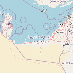
WGS 84 / Dubai Local TM
View EPSG.org definition for EPSG:3997 | Google it
- Type: PROJECTED_CRS
- WGS84 Bounds: 54.84, 24.85, 55.55, 25.34
- Scope: Engineering survey, topographic mapping.
- Area: United Arab Emirates (UAE) - Dubai municipality.
- Projection method name: Transverse Mercator
- Axes: Easting, Northing (E,N). Directions: east, north. UoM: metre.
- Base CRS: EPSG:4326

Leaflet © OpenStreetMap contributors